Deep learning super‑resolution for satellite imagery Market Insights
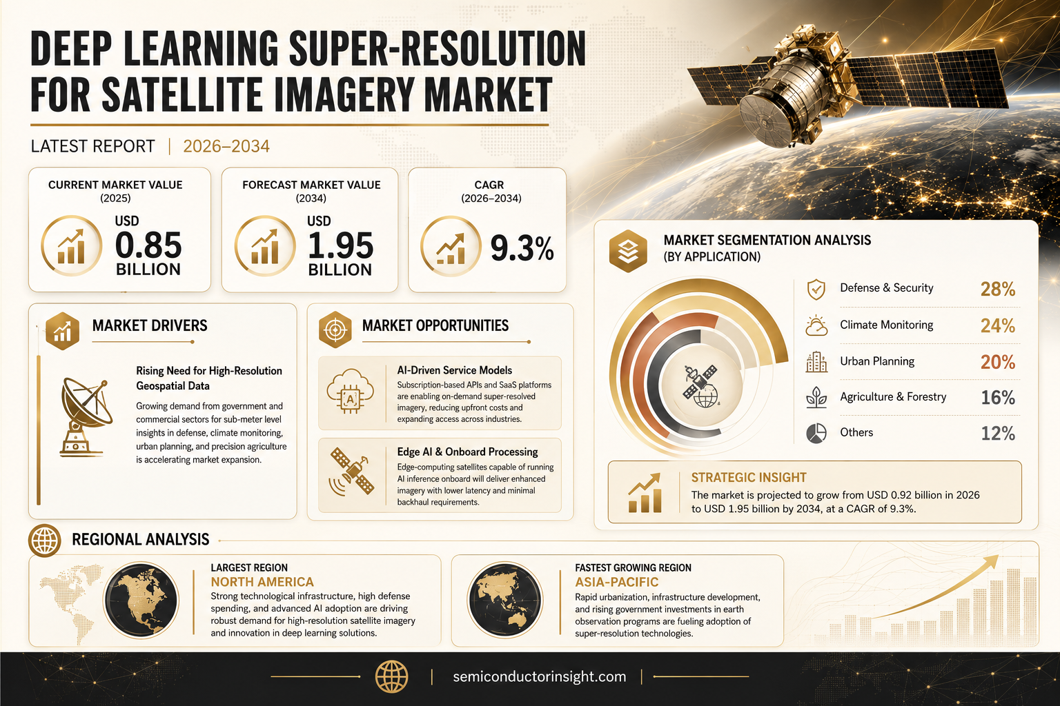
Deep learning super‑resolution for satellite imagery market size was valued at USD 0.85 billion in 2025. The market is projected to grow from USD 0.92 billion in 2026 to USD 1.95 billion by 2034, exhibiting a CAGR of 9.3% during the forecast period.
Deep learning super‑resolution refers to AI‑driven algorithms that reconstruct high‑resolution satellite images from lower‑resolution inputs by learning complex spatial patterns. These models,often based on convolutional neural networks or generative adversarial networks,enhance pixel fidelity, improve feature detection, and enable finer geospatial analysis without additional sensor upgrades.The market is accelerating because governments and commercial operators demand sharper earth observation data for climate monitoring, urban planning, and defense applications. Furthermore, advances in GPU acceleration and cloud‑based AI services reduce deployment costs, while partnerships such as NVIDIA’s collaboration with Maxar Technologies expand solution ecosystems. Key players,including Maxar Technologies, Airbus Defence & Space, Planet Labs, Google Earth Engine, and IBM,are investing heavily in R&D and strategic acquisitions to capture this growing opportunity.
MARKET DRIVERS
Rising Need for High‑Resolution Geospatial Data
Deep learning super-resolution for satellite imagery Market is being propelled by an expanding demand for sub‑meter level detail in sectors such as defense, precision agriculture, and climate monitoring. Governments and commercial operators are investing heavily in imagery that can reveal crop stress, illegal mining, and disaster impacts with unprecedented clarity.
Advancements in GPU Accelerators
Recent breakthroughs in GPU architecture and specialized AI chips have cut training times by up to 60 %, enabling more sophisticated super‑resolution models to be deployed at scale. This hardware momentum directly reduces the time‑to‑value for satellite operators adopting deep‑learning pipelines.
➤ “When processing power aligns with algorithmic innovation, the resolution ceiling of satellite imagery is effectively redefined.”
Overall, the convergence of strategic demand and technology readiness creates a robust growth foundation for Deep learning super-resolution for satellite imagery Market, positioning it for a projected CAGR above 12 % through the next five years.
MARKET CHALLENGES
Technical Complexity and Model Generalization
Developing models that perform uniformly across diverse terrains,urban, desert, forest, and maritime,remains a core obstacle. Variability in sensor characteristics and atmospheric conditions often forces analysts to fine‑tune architectures for each mission, inflating development cycles.
Other Challenges
Computational Cost
Training state‑of‑the‑art super‑resolution networks can require dozens of GPU‑years, translating into operational expenditures that exceed the budgets of smaller satellite firms.
MARKET RESTRAINTS
High Cost of Cloud Compute Infrastructure
While cloud platforms offer elastic resources, the per‑hour pricing for high‑end GPUs can erode profit margins, especially when processing terabytes of raw imagery daily. Companies often face a trade‑off between latency and cost.Additionally, data egress fees associated with moving processed imagery from cloud to on‑premise systems further constrain the economic viability of large‑scale deployments.These financial pressures act as a restraint on the broader adoption of Deep learning super-resolution for satellite imagery Market, prompting firms to explore hybrid on‑premise solutions.
MARKET OPPORTUNITIES
Emerging AI‑Driven Service Models
Subscription‑based APIs that deliver super‑resolved tiles on demand are gaining traction, allowing end‑users to bypass heavy upfront infrastructure costs. This SaaS approach accelerates market penetration among agritech and urban‑planning firms.Furthermore, integration with edge‑computing satellites,where inference runs onboard,opens new revenue streams by delivering enhanced imagery directly from orbit, reducing latency and back‑haul requirements.These opportunities suggest a fertile landscape for innovators to capture value in Deep learning super-resolution for satellite imagery Market over the coming decade.Deep learning super-resolution for satellite imagery Market Trends
Rapid Adoption Fueled by Public and Commercial Demand
Deep learning super-resolution for satellite imagery Market is experiencing a marked acceleration as governments and commercial operators prioritize higher‑resolution Earth observation data. Climate‑monitoring programs require finer spatial detail to track subtle environmental changes, while urban planners depend on clearer imagery to model infrastructure growth. Defense agencies are likewise expanding their use of super‑resolution techniques to improve target identification without deploying new satellite constellations. At the same time, the diffusion of affordable GPU hardware and scalable cloud AI services has lowered entry barriers, enabling smaller firms to integrate advanced up‑sampling models into existing workflows. This convergence of policy support, operational need, and technology readiness is shaping a robust growth trajectory for the market.
Other Trends
Advancements in Neural Network Architectures
Recent breakthroughs in convolutional neural networks (CNNs) and generative adversarial networks (GANs) are central to the market’s evolution. Researchers have introduced residual‑in‑residual designs that preserve texture while minimizing artifacts, and perceptual loss functions that align reconstructed images with human visual perception. Coupled with mixed‑precision training, these innovations deliver superior pixel fidelity with reduced computational overhead. Cloud‑based AI platforms now provide pre‑trained super‑resolution models that can be fine‑tuned on specific sensor data, allowing operators to achieve near‑real‑time processing. This technical progress not only enhances feature detection for applications such as flood mapping and vegetation indexing but also extends the useful lifespan of legacy satellite sensors, further driving market adoption.
Strategic Partnerships Expanding the Solution Ecosystem
Collaboration among hardware manufacturers, data providers, and software developers is intensifying, creating a more integrated ecosystem for the Deep learning super‑resolution for satellite imagery Market. Notable alliances include joint ventures between leading GPU vendors and major Earth‑observation companies, which bundle accelerated inference engines with curated training datasets. These partnerships accelerate time‑to‑market for end‑users by offering turnkey solutions that combine high‑performance processing, secure data pipelines, and application‑specific analytics. Additionally, open‑source initiatives are fostering community‑driven enhancements, while enterprise‑grade service contracts ensure continual model updates and compliance with evolving regulatory standards. The synergy of these collaborative efforts is expected to broaden deployment across sectors, reinforcing the market’s long‑term resilience.
COMPETITIVE LANDSCAPE
Key Industry Players
Deep Learning Super‑Resolution for Satellite Imagery – Competitive Overview
The market is currently dominated by a handful of vertically integrated providers that combine large earth‑observation constellations with deep‑learning research capabilities. Maxar Technologies leverages its WorldView platform and a proprietary super‑resolution pipeline that boosts spatial detail by up to 4×, positioning it as the de‑facto benchmark for commercial high‑resolution services. Airbus Defence & Space complements its SPOT and Pleiades assets with AI‑enhanced processing, while Google Earth Engine offers cloud‑native super‑resolution APIs that democratize access for government and enterprise users. IBM’s partnership network, anchored by GPU‑accelerated IBM Power Systems, further solidifies a tier‑one ecosystem where end‑to‑end workflow integration drives recurring revenue. These leaders control the majority of high‑value contracts in defense, climate monitoring, and urban planning, establishing a clear market hierarchy.Beyond the top tier, several niche innovators contribute specialized capabilities that enhance the overall value chain. Planet Labs applies lightweight convolutional models to its daily‑revisit constellation, improving temporal consistency. Iceye’s synthetic‑aperture radar data is combined with generative adversarial networks to restore detail in cloudy conditions. Descartes Labs, Capella Space, BlackSky, Satellogic, UrtheCast, e‑GEOS, Earth‑i, and emerging startups such as SynthAI and Orbital Insight provide complementary services ranging from rapid analytics to domain‑specific model fine‑tuning. These players, while smaller in revenue, are critical for vertical markets that demand rapid deployment, bespoke training data, or multi‑sensor fusion.
List of Key Deep Learning Super‑Resolution for Satellite Imagery Companies Profiled
- Maxar Technologies
- Airbus Defence & Space
- Google Earth Engine
- IBM
- Planet Labs
- Iceye
- Descartes Labs
- Capella Space
- BlackSky
- Satellogic
- UrtheCast
- e‑GEOS
- Earth‑i
- SynthAI
- Orbital Insight
Segment Analysis:
| Segment Category | Sub-Segments | Key Insights |
| By Type |
|
GAN‑Based Super‑Resolution
|
| By Application |
|
Climate Monitoring
|
| By End User |
|
Government Agencies
|
| By Deployment Mode |
|
Cloud‑Based Services
|
| By Technology Integration |
|
GPU‑Accelerated Pipelines
|
Regional Analysis: North America
The defense and security sector constitutes a significant driver for deep learning super-resolution in North America. Enhanced reconnaissance, surveillance, and target identification rely heavily on high-resolution satellite imagery, making advanced upscaling techniques crucial. The need for detailed analysis of potential threats and monitoring of critical infrastructure is accelerating the adoption of these technologies.
Environmental monitoring is another key application area, particularly relevant in North America’s diverse landscapes. Deep learning super-resolution enables more accurate assessment of deforestation, urban sprawl, disaster response, and climate change impacts. The ability to discern finer details in satellite imagery provides valuable data for informed decision-making in environmental management.
The geospatial analytics and mapping sector leverages deep learning super-resolution to create more detailed and accurate maps. This is particularly beneficial for urban planning, infrastructure management, and resource allocation. The integration of super-resolution improves the clarity and utility of satellite-derived geospatial data.
Scientific research in fields like remote sensing, precision agriculture, and urban ecology benefits greatly from deep learning super-resolution’s ability to extract subtle details from satellite imagery. Enhanced data resolution unlocks new avenues for scientific discovery and understanding of complex environmental processes.
North America
With a significant investment landscape and strong academic institutions, North America is at the forefront of developing and deploying deep learning super-resolution solutions for satellite imagery. This region’s commitment to technological advancement ensures sustained growth in the market. The focus on practical applications and strong collaborations between research and industry leaders further solidify North America’s position. The market’s expansion benefits from continuous innovations in AI algorithms and increased accessibility to high-resolution satellite data.
Europe
Europe is witnessing steady growth in Deep learning super-resolution for satellite imagery Market, driven by stringent environmental regulations and increasing demand for precision agriculture. The region’s focus on sustainable development and resource management creates a strong need for advanced geospatial analysis techniques. European players are actively investing in research and development to enhance their capabilities in this field.
Asia-Pacific
The Asia-Pacific region presents substantial growth opportunities due to rapid urbanization and increasing investments in infrastructure development. The rising demand for smart city initiatives and precision agriculture programs is fueling the adoption of deep learning super-resolution for satellite imagery. Government initiatives promoting digital transformation are further accelerating market expansion.
South America
South America is experiencing growing interest in deep learning super-resolution for satellite imagery, particularly for monitoring agricultural land use and deforestation. The region’s vast geographical area and diverse ecosystems necessitate effective remote sensing solutions for sustainable resource management. Increased cloud computing accessibility is contributing to the wider adoption of these technologies.
Middle East & Africa
The Middle East & Africa region is witnessing increasing adoption of deep learning super-resolution for satellite imagery, primarily for applications in oil and gas exploration, infrastructure monitoring, and urban planning. Government investments in smart infrastructure projects and a growing awareness of the benefits of geospatial analytics are driving market growth.
Report Scope
This market research report provides a comprehensive analysis of the Deep learning super-resolution for satellite imagery Market , covering the forecast period 2026–2034. It offers detailed insights into market dynamics, technological advancements, competitive landscape, and key trends shaping the industry.
Key focus areas of the report include:
- Market Overview: The report begins with an overview outlining its current market scenario, key growth indicators, and industry transformation drivers. It discusses macroeconomic factors, demand–supply balance, regulatory landscape, and the strategic role of semiconductors in powering advancements across industries such as automotive, telecommunications, consumer electronics, and industrial automation.
- Market Size & Forecast: Historical data and future projections for revenue, unit shipments, and market value across major regions and segments.
- Segmentation Analysis: Detailed breakdown by product type, technology, application, and end-user industry to identify high-growth segments and investment opportunities.
- Regional Insights: Insights into market performance across North America, Europe, Asia-Pacific, Latin America, and the Middle East & Africa, including country-level analysis where relevant.
- Competitive Landscape: Profiles of leading market participants, including their product offerings, R&D focus, manufacturing capacity, pricing strategies, and recent developments such as mergers, acquisitions, and partnerships.
- Technology Trends & Innovation: Assessment of emerging technologies, integration of AI/IoT, semiconductor design trends, fabrication techniques, and evolving industry standards.
- Market Drivers & Restraints: Evaluation of factors driving market growth along with challenges, supply chain constraints, regulatory issues, and market-entry barriers.
- Stakeholder Insights: Insights for component suppliers, OEMs, system integrators, investors, and policymakers regarding the evolving ecosystem and strategic opportunities.
Primary and secondary research methods are employed, including interviews with industry experts, data from verified sources, and real-time market intelligence to ensure the accuracy and reliability of the insights presented.
FREQUENTLY ASKED QUESTIONS:
What is the current market size of Deep learning super-resolution for satellite imagery Market?
-> Deep learning super-resolution for satellite imagery Market was valued at USD 0.85 billion in 2025 and is expected to reach USD 1.95 billion by 2034.
Which key companies operate in Deep learning super-resolution for satellite imagery Market?
-> Key players include Maxar Technologies, Airbus Defence & Space, Planet Labs, Google Earth Engine, and IBM, among others.
What are the key growth drivers?
-> Key growth drivers include demand from governments and commercial operators for higher‑resolution earth observation, climate monitoring, urban planning, defense applications, advances in GPU acceleration, and cloud‑based AI services.
Which region dominates the market?
-> The market is globally distributed with strong adoption across North America, Europe, and Asia‑Pacific, without a single dominant region reported in the reference.
What are the emerging trends?
-> Emerging trends include AI‑driven super‑resolution algorithms, GPU‑accelerated inference, and cloud‑based AI service deployments that lower adoption barriers.

Get Sample Report PDF for Exclusive Insights
Report Sample Includes
- Table of Contents
- List of Tables & Figures
- Charts, Research Methodology, and more...